1967 Aerial views of the Nike Site and Indian Hill school
Milwaukee County has some neat historical aerial maps:
https://gis-mclio.opendata.arcgis.com/datasets/MCLIO::1967-aerial-photo
The one from 1967 shows the Nike Hercules anti-aircraft missile site (and the radar used to guide it) - these were located across the street from Indian Hill school. I mentioned this before:
https://wb9kzy.blogspot.com/2022/03/no-squiggly-roof-on-nike-site.html
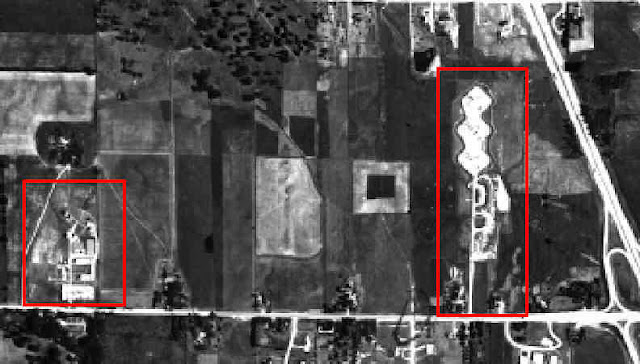
Here was the best aerial view I had, from the very interesting nikesite.org site:
 |
| source: http://www.nikesite.org/page17.html |
The radar is the red box on the left, the missile site is on the right and my old school is barely visible at the lower right. The main road connecting them is Brown Deer road in River Hills, a suburb of Milwaukee, WI. The highway on the right is now I-43.
But here I (inexpertly) stitched together several screens of aerial views from 1967 of the missile site with Indian Hill school at the bottom:
 |
| The Nike site at the top/middle and Indian Hill school at the bottom right |
The three missile batteries can be seen at the top, all you could see at street level were earthen berms. Some kids said they saw the missiles raised into firing position regularly but I (of course) missed that.
And here is the radar installation down Brown Deer road to the west.
 |
| The radar installation to the west |
On the other side of the street from the radar was Lynden, the Bradley estate (one of the Bradleys of the Allen-Bradley company).
I know I'm the only one fascinated by the fact that there was a missile base across the street from little kindergartners and first graders in 1961. With atomic tipped weapons within walking distance it's no wonder that we weren't taught to duck and cover :)
Best Regards,
Chuck, WB9KZY
http://wb9kzy.com/ham.htm