Posts

Showing posts with the label aerial photography

The Polo Grounds in 1910

Image
Here is a really neat picture on Shorpy dot com of the Polo Grounds in 1910: https://www.shorpy.com/node/27869 See the circled area here: Here is an enlargement: There appear to be 4 people up on the roof watching the event !  I suppose this kind of thing happens all the time but rarely is it captured on film. To the west is the higher ground of Coogan's Bluff where I suspect the camera (5x7 cameras are pretty heavy) is setup.  The view is to the south and east.  Manhattan has higher terrain proceeding north.  General Washington's army beat the red coats in the Battle of the Harlem Heights but that's on the western side of the island.  Washington Island terrain is higher to the south-east (that's why there is a cell tower on the "mountain" ;). I imagine the island terrain sculpting was from glaciation in both cases. Here are some aerial views, first setup for baseball it's easy to see why Willie Mays had to cover a LOT of ground to catch those fly balls: N...
1967 Aerial views of the Nike Site and Indian Hill school

Image
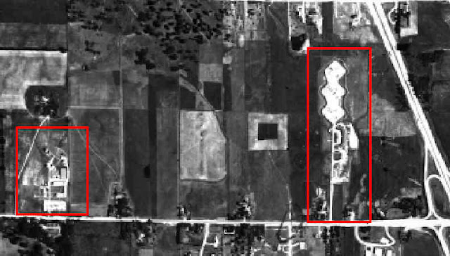
 Milwaukee County has some neat historical aerial maps: https://gis-mclio.opendata.arcgis.com/datasets/MCLIO::1967-aerial-photo    The one from 1967 shows the Nike Hercules anti-aircraft missile site (and the radar used to guide it) - these were located across the street from Indian Hill school.  I mentioned this before: https://wb9kzy.blogspot.com/2022/03/no-squiggly-roof-on-nike-site.html   Here was the best aerial view I had, from the very interesting nikesite.org site: source: http://www.nikesite.org/page17.html   The radar is the red box on the left, the missile site is on the right and my old school is barely visible at the lower right.  The main road connecting them is Brown Deer road in River Hills, a suburb of Milwaukee, WI.  The highway on the right is now I-43. But here I (inexpertly) stitched together several screens of aerial views from 1967 of the missile site with Indian Hill school at the bottom: The Nike site at the top/middle an...

No squiggly roof on the Nike site

Image
 I was searching on Facepalm for pictures of the Nike site that was across the street from where I went to first grade in 1961/1962 (Indian Hill School, River Hills, WI), didn't find any this time. Here is a picture I found online a while back, the Nike site outlined in red (the missiles hidden behind earthen berms were on the right, the radar was on the left), the school I went to is at the bottom right: the Nike sites on Brown Deer road, River Hills WI   Here is a larger aerial picture of the school I found on Ebay, note the driveway shape: Indian Hill School, Brown Deer road, River Hills WI 1960 I understand that in the 1960s three batteries of Nike Hercules missiles were based at the River Hills site.  The Nike Hercules had atomic bomb payloads used to bring down enemy planes coming south over the pole.  And those missiles were across the street (OK almost a highway, Brown Deer road in River Hills WI) from a little school with kindergarteners and first graders, ...